Gerrymandering: Beyond the Partisan Divide
By Elliott Gluck
Associate Editor, Volume 23

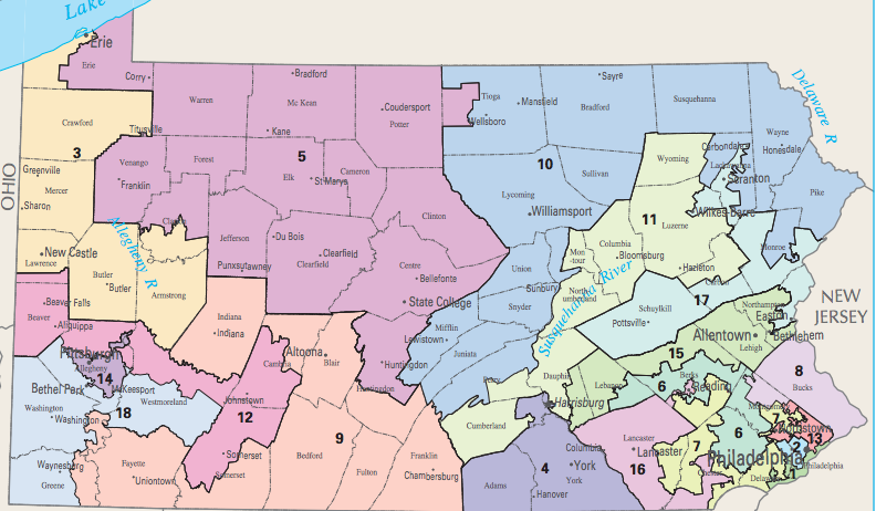
Pennsylvania’s old Congressional map.
Pennsylvania has a long history of a fierce partisan political divisions, due in part to its extremely diverse electorate, geography, and economy.[1] This divide results in massive campaign spending each election cycle and has earned Pennsylvania the label of a battleground or purple state every four years.[2] With this background in mind, it should be no surprise that Pennsylvania is a hub for the practice of gerrymandering which often has a disproportionate effect on communities of color. For partisan gerrymandering, “[t]he playbook is simple: Concentrate as many of your opponents’ votes into a handful of districts as you can, a tactic known as ‘packing.’ Then spread the remainder of those votes thinly across a whole lot of districts, known as ‘cracking.’”[3] Fortunately, the Pennsylvania Supreme Court has stepped in, dubbing the Republican created map used over the last six years unconstitutional.[4] In turn, the Court redrew a far more equitable map that may provide a model for nonpartisan redistricting in years to come.[5]

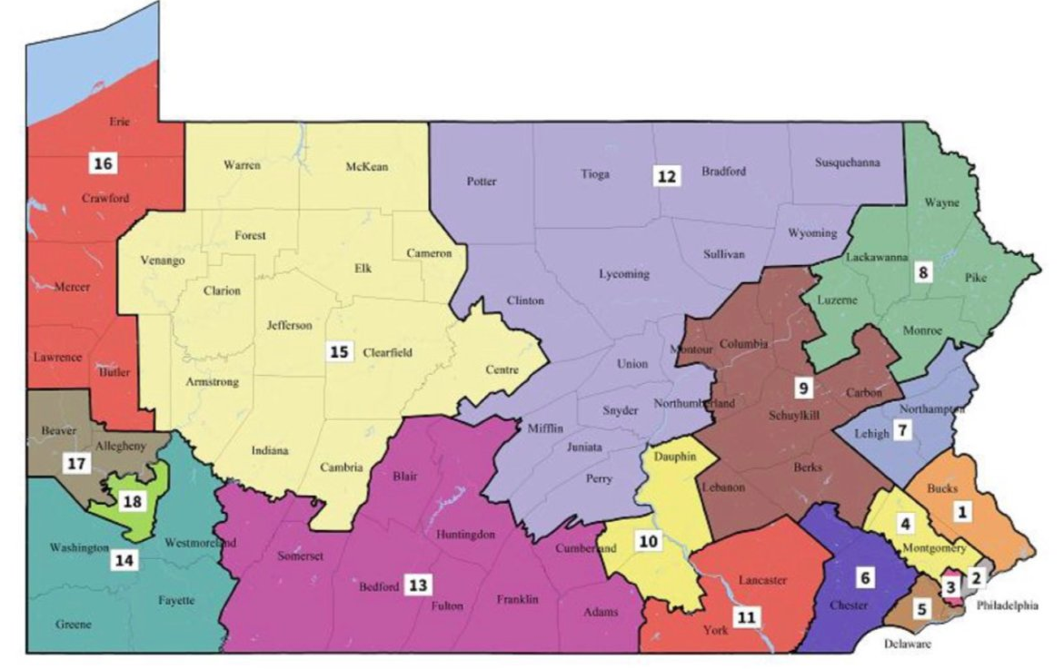
The new Congressional map drawn by the Pennsylvania Supreme Court in the wake of its recent decision.
The new map moves away from the fracturing of communities into disparate districts like the Republican map and attempts to keep counties and municipal areas intact when establishing congressional districts.[6] While the Republican drawn map split 28 of Pennsylvania’s 67 counties into separate congressional districts, the new map will only divide 13.[7] An analysis conducted by the Washington Post finds that the new map erases many of the zig-zag lines that were commonplace under the Republican plan, especially in and around urban areas, and eliminates over 1,100 of electoral boarders, a reduction of approximately 37 percent.[8] This focus on compact districts and keeping communities intact when drawing congressional lines is especially notable in Philadelphia, where the new map splits the city into fewer districts.[9] Each of these changes moves towards congressional districts looking “geographically normal,” a goal shared by many nonpartisan experts in the field.[10] Under the new map, districts are defined by strong community ties, unlike the old map where a seafood restaurant held the seventh congressional district “together like a piece of Scotch tape.”[11]
America’s history of disenfranchising minorities and diluting their political power is undeniable. Although some attempts to create minority-majority districts were intended to empower minorities in the political process, packing minorities into a single district without regard for community composition can decrease minority influence in surrounding districts.[12] Even gerrymandering efforts that aren’t overtly driven by race tend to turn districts surrounding urban areas into shapes resembling those made by a child on an Etch A Sketch. Fortunately, nonpartisan efforts to end gerrymandering practices that divide neighborhoods and leave communities of color with deflated political power are not limited to Pennsylvania. A federal district court in Wisconsin set up the model for the Pennsylvania Supreme Court by using “efficiency gap” metrics to determine just how partisan congressional maps can be.[13] This is an essential step in the right direction to ensure free and fair elections as it gets to the effect of gerrymandering rather than just the process, which can be far easier to disguise in order to avoid judicial scrutiny.
[1] Daniel Bush, ‘Are We a Red State or a Blue State?’ Life in a Pennsylvania Swing County 100 Days into Trump’s Presidency, PBS (Apr. 29, 2017), https://www.pbs.org/newshour/politics/red-state-blue-state-life-pennsylvania-swing-county-100-days-trumps-presidency.
[2] Id.
[3] Issie Lapowsky, The Geeks Who Put a Stop to Pennsylvania’s Partisan Gerrymandering, Wired (Feb. 20, 2018), https://www.wired.com/story/pennsylvania-partisan-gerrymandering-experts/.
[4] Christopher Ingraham, Pennsylvania Supreme Court Draws ‘Much More Competitive’ District Map to Overturn Republican Gerrymander, Wash. Post (Feb. 20, 2018), https://www.washingtonpost.com/news/wonk/wp/2018/02/19/pennsylvania-supreme-court-draws-a-much-more-competitive-district-map-to-overturn-republican-gerrymander/?utm_term=.ed79d4b3d7f9.
[5] Id.
[6] Id.
[7] Lila Thulin, The Pennsylvania Supreme Court Just Released Its Newly Fair Congressional Map, Slate (Feb. 19, 2018), https://slate.com/news-and-politics/2018/02/pennsylvania-supreme-court-issues-congressional-map-in-gerrymandering-case.html.
[8] Christopher Ingraham, New Pennsylvania Congressional Map Erases 1,100 Miles of District Borders, Wash. Post (Feb. 20, 2018), https://www.washingtonpost.com/news/wonk/wp/2018/02/20/new-pennsylvania-congressional-map-erases-1100-miles-of-district-borders/?utm_term=.f3c22d228ceb.
[9] Thulin, supra note 7.
[10] Lapowsky, supra note 3.
[11] Id.
[12] Kim Soffen, How Racial Gerrymandering Deprives Black People of Political Power, Wash. Post (June 9, 2016), https://www.washingtonpost.com/news/wonk/wp/2016/06/09/how-a-widespread-practice-to-politically-empower-african-americans-might-actually-harm-them/?utm_term=.ba0570822bb2.
[13] Ed Kilgore, The Debate Over Gerrymandering is Changing in a Fundamental Way, New York (Feb. 20, 2018), http://nymag.com/daily/intelligencer/2018/02/the-debate-over-gerrymandering-is-fundamentally-changing.html.
